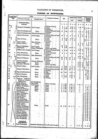
Montiaghs ~ Griffith's Land Valuations 1864

The name Montiaghs is an anglicisation of Mointeacha meaning moorlands, mosslands or boglands. Montiaghs parish comprises of 18,098 Statute acres. It is in the Barony of Oneilland East and the Poor Law Union of Lurgan.
The Montiaghs received creditable mention in Lewis's Topographical Dictionary of Ireland in 1837. At that time, the area was described as a Parish in the Barony of Oneilland East, County Armagh, four miles north-west from Lurgan, on the road to Stewartstown, by way of the Bannfoot ferry.
The Parish, which then had 2,891 inhabitants, is situated on the southern shore of Lough Neagh and bonded on the south-west by the River Bann. An extract from Archdeacon Atkinson’s address, at the opening of an Ardmore Parish Church Bazaar in 1912, reads: "In 1765, ten townlands bordering on the lough were cut off from the Parish of Seagoe and formed into a Parish of their own, called the Montiaghs, the meaning of which is ‘bog-lands'.
"Eight of these townlands begin with the prefix Derry which means a large oak wood, so that, in the Parish at that time, there were eight oak woods and plenty of boggy lands as the word Montiaghs implied". The townlands in question have remained as Derryadd, Derrymacash, Derrycor, Derrytagh North, Derrytagh South, Derrytrasna, Derryloiste, Derryinver, Ardmore and Ballynery. Lewis adds: "It comprises, according to Ordinance Survey, including islands, 18,098¼ statute acres, of which 12,178 are in Lough Neagh, 305½ in Lough Gullion and 83 in the River Bann".
Click on a name on the right to see the records, or type a surname in the search box below.


|